Dog walking in Swaledale

Where to walk your dogs in Swaledale
Of course you don’t need dogs to do these walks! These are all relatively easy walks of varying lengths. Personally I take Skye (now Luna) the dog down to the river at Isles Bridge (5 minutes walk) each morning so she can have a swim. Watch out if its been raining as a lot of the land will disappear under rapidly rising water levels!
A lot of these local walks cross over each other so combine them to make new routes. Most of all, enjoy them. They are all pretty easy walking with the odd steepish hill but that’s about it.
Thanks to Ordnance Survey Maps for helping us out so you can click on the links for each walk and see them in more detail.
The Pathfinder books has a series o circular walks in the Yorkshire Dales.
More suggested walks are featured in our Swaledale Bridges page.
Skye pictured above Semer Water, itself really nice circular walk and good for a wild swim!

Blades and Back
Start and finish at the green dots, Swale View. Walk onto the main road, turn right and then sharp left up the track. Follow round and up. You go through a gate by a house and up and across a field rejoining the road.
Takes about 30 mins, unless you stop off at the Punch Bowl en route. It is over half way so you have earned a drink. Bit of a steep climb up to the top, but great views from Blades across the valley.
Watch out at the start for the wee ford/waterfall you can cross by foot or use the foot bridge to the right if it has been raining.
Ordnance Survey Map link here. Grid Ref: SD 98220 98029
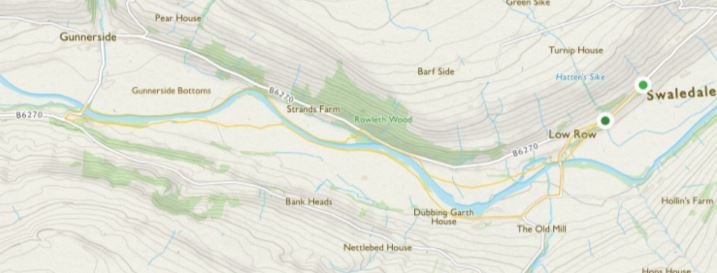
Isles bridge to Gunnerside
This is a nice easy walk done either way. Walk onto the main road, left towards Gunnerside, left down towards Crackpot. At Isles bridge go through the stile on the right hand side. Walk across the ‘beach‘ (if it’s been raining use stepping stones or go home if fields flooded!) follow the river on the left and use the way markers.
You will be diverted onto the road for about 150 m, back left through a stile into a field that descends to the river. At Gunnerside bridge cross the stepping stones, back over the bridge up the hill and left onto the Swale Trail. Back then to Isles bridge following the river on your left. Takes about 1.5 hours. Or turn left at Gunnerside Bridge to go into the village. Only 5 minutes walk. Ordnance Survey Map link here. Grid Ref: SD 97469 97551
This is a good stretch to watch out for Kingfisher birds - check out our birdwatching in Swaledale page!

Surrender Bridge Circular
A straight forward walk, about 1.5 to 2 hours. You can walk from Swale View, adds about 40 mins, but for the shorter route take the steep road just past the Punch Bowl up towards Arkengarthdale. Park up on the road to the right signposted Reeth 3 miles, there is space for about 10 cars on the verge. Walk down to the bridge, cross it and basically follow the elevated track up on the right along the stream (which is now on your left) past the old lead mines bearing right (there are a couple of forks, always bear right) and up over the top of the hills. A bit bleak and blowy on top but some nice views across the moor for a 360 degree different perspective. Head down to join the road, turn right back to the bridge.
Ordnance Survey Map link here. Grid Ref: NY 99428 01147

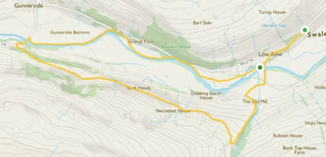
Isles Bridge Circular
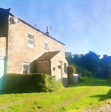
This is a good 1.45 hr walk, start off at Isles Bridge and take the left hand swing gate along the Swale. Walk alongside the Swale atop a wall part of the way, and into Feetham Wood. The route doubles back sharply and upwards to the road. Bear right to the sign for Askrigg, cross over the bridge, turn right and walk a wee while, it’s signposted for the Swale Trail. Bear right at a junction still on the Swale Trail and back to Isles Bride. Look to the left on the way out for the red door of the Swale View Barn and Swale View behind, and to the right on the way back. Cyclist aplenty (ish) on weekends on the trail so be aware.
Ordnance Survey Map link here. Grid Ref: SD 99314 97927

Swale View to Surrender Bridge via Blades
As before trot off to Blades by going up the track just behind the house. In Blades take the first left turn towards the houses on the right (but not the road to them) and then fork right.
Go past the standalone cottages on your right and bear right behind them, keep bearing right past a barn on your right and the track forks right. Follow for about 1.5km and it rejoins the road to Surrender Bridge. About 35 mins from Low Row to Surrender Bridge.
Ordnance Survey Map link here. Grid Ref: SD 99265 98847

Punch Bowl to CB Inn via the ‘James Herriot’ ford
For those who, like me, are fans of All Creatures Great and Small, where I was first exposed to the Yorkshire Dales, you may be interested in visiting the ford which appears on the opening credits as James and Siegfried drive through it. Only about 25 minutes walk along the road from the Punch Bowl, bit of a steep start, walk over Surrender Bridge, up a wee hill on the road and then drop down again into the ford.
Its a popular (all relative) picnic spot, plenty of space to park and have a nice lunch by the stream. Or carry on walking to the sister pub of The Punch Bowl the Charles Bathurst for lunch or dinner. About another 20 minutes from the Ford.
Ordnance Survey Map link here. Grid Ref: NZ 00061 00890

Fremington To Marrick
Via Marrick Priory. Nice easy walk, can get blustery on top though.
Park in Fremington on the left once out of Reeth in the triangle area by the junction of the road to High Fremington. Head off up to High Fremington and drop down to the Hard Stiles Road. Take that, go past the farm on your right and walk to Marrick Priory on also on your right. Once you have gone past that go over, or round, a cattle grid and head up the track to the left into the forest and up the Nuns Steps in the forest. Once you pop out the other side keep walking uphill, through some gates back onto a road into Marrick. Bear left and go past a farm on you left which ultimately takes you onto the road back to Fremington. However, about 250 metres after the farm look for a style on your left, this goes into some fields, jump in there, keep going straight ahead veering into a field on your right and bingo you will hit the road again. On the map to the left you come out to the right of the Reels Head Farm. It’s easier than it sounds. Walk is about one hour twenty minutes. Ordnance Survey Map link here. Grid Ref: SE 06961 98468

Isles bridge to Summer Lodge Tarn
Ok, hands up, not done this one yet but on my to do list. Only found out about the Tarn the other day. Should be a straight forward walk, albeit steep up Haverdale Beck but you are on a road. Follow signs for Summer Lodge, keep walking and onto a track and eventually turn right before you get to the tarmac of Long Road.
I will update once I have been and let you know how it is up there!
Ordnance Survey Map link here. Grid Ref: SD 97352 96193
Crackpot falls and onto Gunnerside
Take the usual route to Isles Bridge, left out of the house on the main road, left turn down to the bridge signposted Crackpot, keep walking and follow the road up to Summer Lodge. The falls are off a track to the left as you ascend the hill in Haverdale Beck. If it’s been raining they are amazing and so powerful.
Keep walking up the hill on the road again and follow the signpost to Gunnerside and Muker. You get some nice views over to the right. Walk to Gunnerside Bridge and then follow either on the road or right by the river.
Ordnance Survey Map link here. Grid Ref: SD 97459 97281